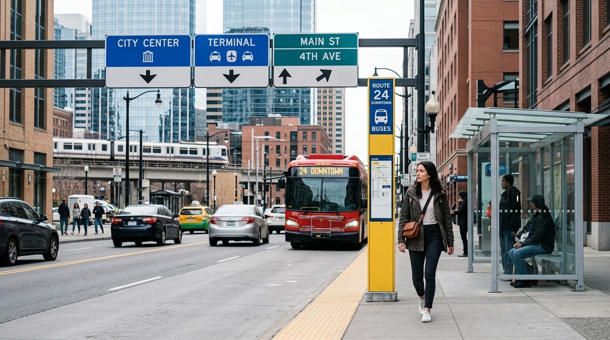
You step off the subway in a neighborhood you have never visited. Your phone battery just hit zero. The street signs are in a language you barely recognize. Instead of panic, you take a breath and look around. The cars are moving in a steady rhythm. A city bus rumbles past with a route number on its side. The street itself widens ahead, and the sidewalks are busy with people heading in one direction. In that moment, you realize the city is talking to you. You just need to know how to listen. Learning to navigate using traffic and bus routes is one of the most practical skills a traveler or new resident can develop. It works when your phone dies, when data plans fail, or when you simply want to move through a city with more awareness and confidence. This guide will show you how to read the urban landscape like a local.
Traffic patterns, bus routes, and city infrastructure act as a living map if you know what to look for. By observing the flow of cars, the placement of bus stops, and the layout of streets, you can orient yourself without GPS. This guide teaches you how to read these everyday cues to navigate any city with confidence, whether you are a traveler or a new resident learning the lay of the land all around you.
Why Traffic and Bus Routes Act as Clear Directional Cues
Cities are not random. They are built around movement. Roads, public transit lines, and sidewalks form a skeleton that tells you where important places are. Traffic moves toward commercial centers in the morning and away from them in the evening. Bus routes connect neighborhoods to train stations, hospitals, and shopping districts. When you learn to read these patterns, you stop needing a screen to tell you where to go.
Traffic flow is especially useful because it responds to the daily rhythm of a city. If you see heavy traffic moving in one direction at 8 a.m., that road likely leads to a business district or a major employment center. If you see the same road congested in the opposite direction at 5 p.m., you are probably looking at a residential corridor. Over time, these observations become instinct.
Bus routes are even more reliable. They are designed by transit authorities to serve consistent destinations. A bus with a single-digit route number in many U.S. cities often runs along a major artery. A bus with a three-digit number might serve a suburban connection. The signs on the front of the bus tell you the terminal stop. That information is gold when you are lost.
For those who want to strengthen this skill further, reading about how to master urban navigation techniques without using a map can deepen your understanding of how all these cues work together.
How to Read Traffic Flow for Direction and Distance
You do not need a traffic report to understand what the cars around you are saying. You just need to watch for three things: volume, speed, and direction.
Volume tells you importance. A street with constant traffic is a main road. A quiet street is residential or secondary. If you need to reach a central square or a train station, follow the traffic. Cars tend to flow toward destinations.
Speed tells you distance from the core. In most U.S. downtown areas, traffic moves slowly because of lights, pedestrians, and density. As you move away from the center, speeds increase. If you are walking and cars are zooming past, you are likely on an outer road or a highway feeder. If cars are crawling, you are close to the action.
Direction tells you the time of day and the purpose of the road. Morning traffic flows inward. Evening traffic flows outward. If you are walking against the flow in the morning, you are heading away from the city center. That is useful when you want to find a quiet café instead of a crowded business district.
One thing to keep in mind is that one-way streets can trick you. In cities like Boston or San Francisco, a street that only goes one way might still be a major artery. Check the direction of the parked cars. They usually face the direction of traffic. This small detail helps you orient faster.
Using Bus Routes as a Living Map
A bus is more than a ride. It is a moving signpost. Every bus route has a number and a name. The name tells you the destination or the neighborhood it serves. In many U.S. cities, buses also display major intersections along the route.
Here is how to use a bus to orient yourself:
- Find the nearest bus stop. Look for a pole with a route map or a schedule. Even if you cannot read the language, the route map shows you the shape of the line.
- Read the route number and destination. A bus heading toward a familiar landmark, like a downtown terminal or a university, tells you the direction of that landmark.
- Watch the frequency. Buses that come every 10 minutes run on high-demand routes. Those routes usually connect important parts of the city. If you see a bus every 5 minutes, that line likely goes to a transit hub.
- Notice where people get on and off. If a bus stops and many people get off at a certain intersection, that area is significant. It could be a shopping district, a hospital, or a government building.
- Use bus stop spacing as a distance gauge. In dense areas, stops are close together, sometimes every two blocks. In spread-out areas, stops are farther apart. This tells you whether you are in a compact neighborhood or a sprawling one.
Bus routes also change during the day and on weekends. A route that runs every 10 minutes on a Tuesday might run every 30 minutes on a Sunday. Knowing this helps you plan your walking route even if you are not riding the bus.
For a broader look at how to move through cities without technology, check out these top strategies for urban wayfinding when technology fails. They complement the bus-reading skills you are building here.
Infrastructure Clues That Guide You Home
The built environment gives you hints at every turn. Streetlights, sidewalk width, building height, and even the presence of bike lanes all tell a story about where you are.
Street width and sidewalk size are reliable indicators. Wide streets with broad sidewalks usually lead to commercial areas or public squares. Narrow streets with minimal sidewalks are residential. If you are looking for a grocery store or a pharmacy, stay on the wider streets. If you want quiet and shade, turn onto a narrow side street.
Streetlight density matters too. Areas with tall, closely spaced streetlights tend to be pedestrian-friendly zones, often near transit stops or entertainment districts. Areas with fewer or shorter lights are usually less central. If you are walking at night, follow the bright streets. They lead to where people gather.
Building height and age can also guide you. Older, shorter buildings often cluster in historic districts. Newer, taller buildings appear near business centers or along major transit corridors. If you see a sudden shift from old to new, you have crossed a neighborhood boundary. That boundary might be a major street or a highway.
Traffic signal timing is another clue. Pedestrian walk signals that last longer indicate high foot traffic areas. Signals that change quickly are for cars. If you are walking and the crosswalk gives you a full 40 seconds to cross, you are in a place designed for people, not just vehicles.
For those interested in a more sensory approach to navigation, learning how to use foot traffic patterns to navigate any city without a map builds on the same principles of reading the urban environment.
A Step-by-Step Process to Navigate Using Traffic and Bus Routes
When you find yourself in an unfamiliar part of town, follow this process. It works whether you are in New York, Chicago, Portland, or any city with a basic transit system.
- Stop and look for the nearest bus stop or transit sign. Do not walk aimlessly. Find a fixed point first. A bus stop pole gives you route information and often a map.
- Identify the direction of traffic flow. Stand still for 30 seconds and watch which way cars are moving. Compare that to the time of day. If it is 9 a.m. and traffic is heavy in one direction, that direction likely leads downtown.
- Read the bus route signs. Look at the route number and the destination displayed on the front of the bus. If you see a route that ends at a landmark you know, you have a reference point.
- Match the bus route to the street width. Wide streets with bus stops are main corridors. Narrow streets without stops are secondary. Use this to build a mental map of the neighborhood layout.
- Walk one block in the direction of the heaviest traffic or the most frequent bus route. After one block, reassess. Do the street numbers increase or decrease? Do the buildings look more commercial or more residential? Adjust your direction based on what you see.
- Repeat until you hit a landmark you recognize. The goal is not to find your destination immediately. The goal is to build a mental link between the neighborhood and the larger city grid.
“The best navigators in the world are not the ones with the best maps. They are the ones who pay attention to what is already around them. Traffic and buses are the city’s way of showing you where things are. Trust that signal before you trust any app.” — Maria Torres, urban geographer and wayfinding consultant
What to Scan For When You Lose Your Bearings
When you are disoriented, your brain wants to grab onto something familiar. Train yourself to scan for these specific elements in order. They will reorient you faster than any map.
- Bus stop poles with route maps, especially those showing the full route line
- The direction of moving cars, particularly during rush hours
- Street signs at intersections, even if you cannot read the language, the shape and color often follow a standard
- Large intersections with multiple bus stops, those are transit hubs
- Pedestrians walking with purpose, they often head toward transit or shopping areas
- The position of the sun relative to the street direction, it helps you confirm north and south
- Bike racks and scooter parking, they cluster near transit stops and commercial zones
- Trash cans and public seating, they appear more frequently in pedestrian-friendly zones
- The slope of the street, many cities slope toward rivers or downtown areas
Common Mistakes vs Smart Techniques
Here is a table that compares what most people do wrong with what actually works when trying to navigate using traffic and bus routes.
| Mistake | Why It Fails | Smart Technique |
|---|---|---|
| Walking against traffic during rush hour | You fight the natural flow and end up in less populated areas | Let the traffic guide you toward density and services |
| Ignoring bus route numbers | You miss a clear directional signal that is updated daily | Note the route number and the destination sign on every bus you see |
| Assuming all wide streets are safe | Wide streets can be highways with no pedestrian access | Check for crosswalks and pedestrian signals before following a wide road |
| Following crowds without context | Crowds might lead to a stadium or event, not a transit hub | Watch where the crowd goes after the event ends, that reveals transit directions |
| Relying only on building names | Names change, but street patterns stay the same | Use street layout and traffic direction as your primary reference |
| Forgetting that bus routes change on weekends | A route that runs often on weekdays might be sparse on Sunday | Always note the day of the week when using bus frequency as a cue |
How to Practice This Skill Without Leaving Your Neighborhood
You do not need to be lost to practice. Start in your own part of town. Pick a street you know well and observe it as if you were seeing it for the first time.
Write down the bus routes that pass through. Note the direction they go at different times of day. Watch how traffic volume changes between 8 a.m. and 10 a.m. Notice which streets have wider sidewalks and which ones feel more like car corridors.
After a week of casual observation, try this test. Walk to a bus stop you have never used. Read the route map. Without getting on the bus, predict where the route goes based on the street name and the direction the bus is pointing. Then check your prediction with a transit app or a local map. You will be surprised how accurate your guesses become.
For a deeper challenge, try this technique in a city you have never visited. Spend your first 30 minutes walking without your phone. Use only the traffic and bus cues to locate the main square or the transit hub. The first time you succeed, you will feel a level of confidence that no GPS can provide.
If you want to keep building on these skills, you can learn how to develop your urban navigation skills using sound and scent cues as a next step. It adds another layer of awareness to what you already practice with traffic and buses.
Your City Speaks a Language You Can Already Understand
Every city has a rhythm. Traffic ebbs and flows. Buses trace the same lines day after day. Streets widen and narrow according to purpose. These are not random details. They are a language written in concrete, steel, and movement. Once you learn to read that language, you never truly feel lost.
The next time you step out of a train station or a bus terminal, try this. Leave your phone in your pocket for the first five minutes. Watch the cars. Read the bus signs. Notice the shape of the street. Let the city show you where to go. It has been doing that for centuries, long before GPS existed. It still works today, and it will work for you.