Your phone battery hits 3% and you are six blocks from the subway stop you need. The screen flickers and dies. You look up at an unfamiliar intersection. No GPS. No map. No backup battery. For the first time in years you have to rely on your own brain to get home. This is the reality that millions of tech dependent urbanites and preppers are preparing for in 2026. The good news is that human beings navigated cities for centuries without a glowing rectangle. You can learn to do it again. It is not about guesswork. It is about reading the city like a language. And it could keep you safe when your digital crutch disappears.
Urban navigation without phone is a set of learnable skills that combine sun position, landmark recognition, street grid logic, and human interaction. By practicing these techniques for just 15 minutes a day you can build the confidence to move through any American city even when your phone is dead. Your brain is the most reliable navigation tool you own.
Why Your Phone Will Fail You
We treat our phones as if they are permanent. But batteries drain. Screens crack. Networks go down during storms, protests, or outages. In 2026 cities are more connected than ever yet a single dead battery can leave you stranded. Relying solely on a device means you lose spatial awareness. You stop noticing the angle of the sun, the shape of buildings, the flow of traffic. When the phone goes black your mental map is blank. That is a vulnerable place to be. By practicing urban navigation without phone you reclaim that map. You become an active participant in your own journey instead of a passive follower of a blue dot.
The 5 Step Process to Navigate Without a Phone
These steps work in any US city. They assume you have zero digital help and only your senses.
-
Orient yourself using the sun or shadows. In the northern hemisphere the sun rises in the east and sets in the west. At noon it sits roughly south (adjust for daylight saving time). If you see a shadow cast by a vertical object, the shadow points north before noon and east after noon. Practice this daily. It takes ten seconds and gives you cardinal directions.
-
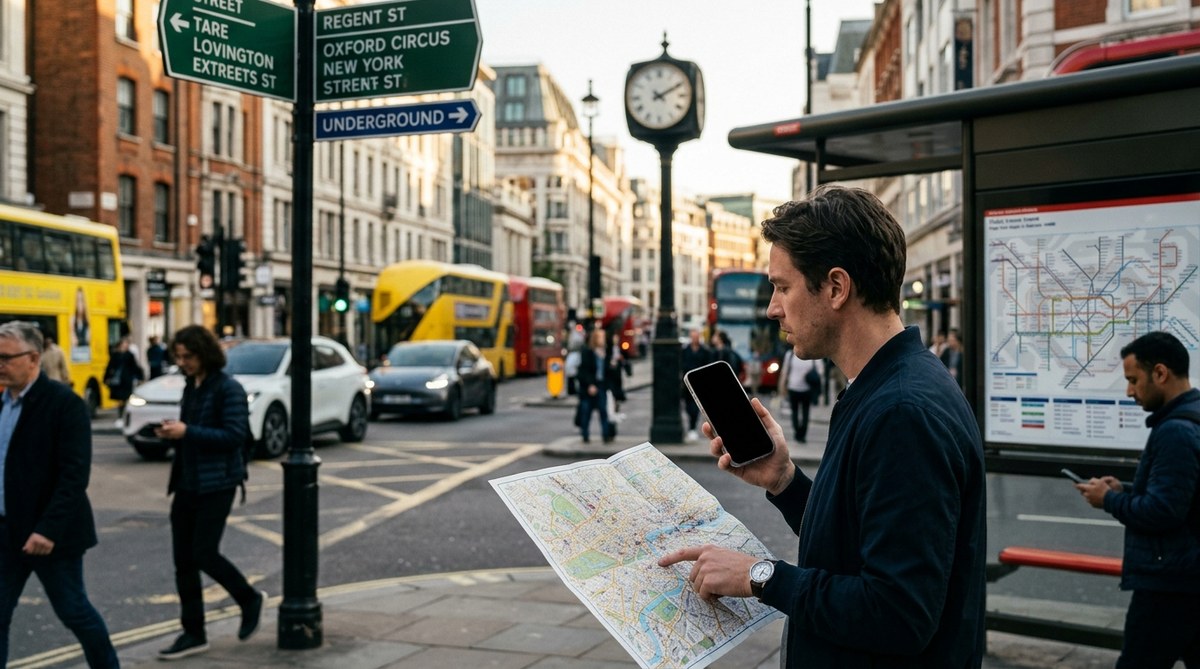
Identify two permanent landmarks. Look for something that will not move: a water tower, a church steeple, a distinctive skyscraper, a bridge, a stadium. Note the direction of these landmarks relative to where you are. For example, if you see the Empire State Building to your left, you know you are facing northeast. This gives you a fixed reference point.
-
Understand the street grid logic. Most US cities follow a grid pattern. Streets run east west, avenues run north south. In Washington D.C. the layout is radial with lettered and numbered streets. In Manhattan the avenues are north south and streets are east west. Learn the naming conventions of your city. If you know that Main Street runs east west, you can deduce which way is which just by reading a sign.
-
Follow transit and infrastructure lines. Subway entrances often point to the direction of the train. Bus stops list route numbers that indicate general direction. Power lines and railroad tracks can act as linear guides. If you follow a bus route that you know goes downtown, you will eventually hit a major intersection. This is a reliable method for urban navigation without phone.
-
Ask a local but use your judgment. Approach a shopkeeper, a mail carrier, or a person who looks familiar with the area. Ask for a specific landmark instead of a street name. For instance, “Which way to the big red water tower?” is better than “Where is Oak Street?” because landmarks are easier to remember and verify. Trust your instinct if someone seems unsure or is giving confusing directions. A second opinion can save you from walking the wrong way.
What to Scan For When Lost
When your phone is dead you need to actively scan your environment. Do not just wander. Look for these cues:
- Distinctive storefronts with unique signage or colors that you can remember
- Police call boxes or public safety kiosks that often have city maps
- Bus stop shelters with route maps printed inside
- Water towers or tall antennas that are visible from multiple blocks
- Building shapes that are unusual (a round tower, a glass pyramid)
- Shadows cast by large structures that indicate time of day and direction
These visual anchors give you waypoints. You can chain them together to build a mental route. Even in a city you have never visited you can collect five such cues in about ten minutes. That is enough to find your way back if you get turned around.
Techniques Versus Common Mistakes
| Technique | Common Mistake |
|---|---|
| Using the sun to find south | Forgetting daylight saving time pushes the sun’s high point later in the day |
| Using landmarks like a church steeple | Choosing a landmark that is blocked by tall buildings after a few blocks |
| Reading street signs for direction | Ignoring directional suffixes such as Street vs Avenue or East vs West |
| Following a crowd toward a transit hub | Following blindly without checking whether the crowd is heading to a nightclub not a station |
| Asking a security guard for help | Assuming everyone knows the area; security guards may be new to the job |
The table shows that even good techniques can fail if you skip a small detail. The key is to combine multiple methods. If the sun is hidden by clouds use the direction of traffic flow or the orientation of building numbers. If a landmark disappears use a different one. Redundancy is your safety net.
Reading Urban Architecture as a Map
Buildings communicate where you are if you know how to look. Older buildings often have street numbers carved into their facades. Corners sometimes display the names of both intersecting streets. In cities like Philadelphia or Boston the architecture shifts noticeably when you cross into a different neighborhood. Red brick row houses may give way to concrete high rises. Pay attention to these transitions. They act as borders on your mental map.
Also note the orientation of building entrances. In many downtown areas the main entrance faces the avenue, not the street. That clue tells you which thoroughfare is primary. If you are walking parallel to the avenue you will see a lot of entrances. When the entrances shift to side streets you have turned. This is a subtle but powerful skill for learning to navigate any US city using only your senses and landmarks.
Using Sound and Smell to Find Your Way
Your ears and nose are underused navigation tools. The hum of a highway tells you a major road is nearby. The rattle of a train indicates a rail line. The smell of a bakery or a coffee roaster can anchor you to a specific block. In many cities the waterfront has a distinct scent of salt or diesel. A sports stadium on game day roars with crowd noise blocks away.
Practice closing your eyes for three seconds when you are on a familiar street. Notice what you hear. You might detect the direction of traffic, the sound of a siren, or the chatter from a restaurant. These audio cues create a mental map that works even in low visibility. When your phone dies you can still hear the city. Use sound and sight cues to navigate urban jungles and you will never feel truly lost.
The Mental Game: Staying Calm Without a Map
Panic is the real danger. When you realize your phone is dead your heart rate jumps. Your brain starts to scramble. That is when people make bad decisions. The antidote is preparation. Before you leave home take ten seconds to note the cardinal direction of your destination. Memorize one major landmark that you can see from the sidewalk. Do this every time you step out. It becomes a habit.
If you do get lost stop moving. Stand still for 30 seconds. Breathe. Look around. Identify three things you recognize or can use as cues. Decide on a direction to walk in based on your best guess. Walk for two blocks. If nothing looks familiar, reverse course. This method of short deliberate moves beats random wandering.
“The best navigation tool is a calm mind. If you memorize the cardinal direction of your destination before you leave, you will never be completely lost. Even a general sense of north or south gives you a framework to work within.” — Sarah M., urban navigation instructor.
How to Practice Without Risk
You do not need a disaster to start learning. Pick a Saturday afternoon and turn off your phone for two hours. Walk to a neighborhood you barely know. Use only the methods above to find your way home. Bring a paper map as a safety net if you want but try not to look at it. Each time you do this you strengthen your brain’s internal GPS.
Start with small distances. Walk two blocks without your phone. Then a half mile. Then a mile. Build up to navigating a whole district. You will be surprised how quickly your spatial awareness grows. For more structured practice check out top tips for developing natural wayfinding skills in urban environments. It turns a liability into a skill.
Keep Your Wits Sharp and Your Eyes Open
Your phone is a convenience not a necessity. The more you depend on it the more fragile your sense of direction becomes. By learning urban navigation without phone you are not just preparing for emergencies. You are reclaiming a part of your own intelligence. The next time your battery dies you will not feel panic. You will look up at the sky, notice the sun, spot a familiar building, and walk with confidence. That feeling of self reliance is worth every minute of practice. So start small. Look up from your screen. Learn the language of your city. Your brain already knows how to find the way home.