You step off the subway in a city you have never visited. Your phone has 3% battery. No data, no map. But you look at the streets and you already have a sense of direction. That is not luck. That is pattern recognition. City street networks follow predictable designs, and once you learn to read them, you can navigate almost anywhere on instinct. This article breaks down the five most common street patterns for navigation. By the end, you will see every city as a code you already know.
Street patterns are not random. Most cities were built using one of five layouts: grid, radial, organic, hybrid, or linear. Recognizing which pattern you are in gives you an instant mental map. You learn to predict where major roads go, where the center lies, and how to find landmarks. This skill lets you drop your phone and trust your own eyes. It works in Boston, Tokyo, or Paris. Master these patterns, and you will never feel lost again.
What Are Street Patterns and Why Do They Matter
Urban planners have used the same basic designs for centuries. A street pattern is the skeleton of a city. It tells you where the main arteries run, where the center is, and how neighborhoods connect. When you know the pattern, you stop guessing. You start predicting.
For example, a grid pattern means you can navigate by cardinal directions and block numbers. A radial pattern points you toward a central hub. Organic streets force you to rely on landmarks. Hybrids mix all of them. Each pattern gives you a different set of clues. The trick is knowing which clues to look for.
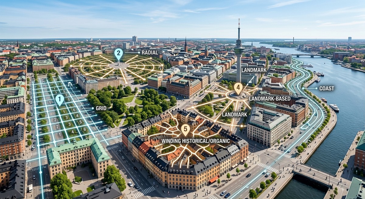
The 5 Most Common Street Patterns You Will Encounter
Here are the five patterns you will see again and again, whether you are walking in a new town or visiting a foreign capital.
- Grid Pattern – Streets run perpendicular to each other in a rectangular layout.
- Radial Pattern – Roads spread outward from a central point like spokes on a wheel.
- Organic Pattern – Streets follow natural terrain, winding irregularly without a plan.
- Hybrid Pattern – A combination of two or more patterns in one city.
- Linear Pattern – Development stretches along a single major corridor.
Each pattern demands a different navigation strategy. Let us examine them one by one.
The Grid Pattern
Think of New York City, Chicago, or Salt Lake City. A grid is the easiest pattern for beginners. Streets run north-south, avenues run east-west (or vice versa). Addresses often follow a number or letter system. Once you know the numbering convention, you can find any intersection without a map.
How to navigate a grid:
– Learn the baseline street (often the main east-west artery like Main Street).
– Use block numbers to measure distance. One block is usually about 1/20 of a mile.
– Count blocks to estimate walking time. Ten blocks is roughly half a mile.
Grids can feel monotonous, but they are forgiving. If you miss a turn, you can always take the next block over. The grid is the map-maker’s favorite pattern.
The Radial Pattern
Paris, Washington D.C., and Moscow all use radial designs. Streets converge on a central point like a plaza, a monument, or a traffic circle. To navigate a radial city, you must locate the hub. Once you know where the center is, you can orient yourself by the spokes.
How to navigate a radial pattern:
– Find the main circle or square. This is your anchor.
– Understand that major avenues radiate from the hub. They often have names like “Boulevard de la…” or “Constitution Avenue.”
– Be aware that cross streets form concentric rings. Smaller rings are closer to the center.
Radial patterns can be disorienting because streets cross at odd angles. But they are also beautiful: a single landmark gives you your entire bearing. If you can see the Eiffel Tower or the Washington Monument, you know exactly which direction the center lies.
The Organic Pattern
Boston, London, and many old European cities grew organically. Streets followed cow paths, rivers, and ridge lines. There is no rhyme or reason to the layout. This pattern feels chaotic, but it has its own logic.
How to navigate organic streets:
– Forget about straight lines. Use landmarks as your main guide.
– Notice that major thoroughfares often follow old trade routes. They may change names multiple times.
– Water features (rivers, canals, bays) act as natural boundaries. Learn where the water is and you will never get completely lost.
Organic patterns reward the observant. You need to build a mental map of notable buildings, parks, and plazas. But once you do, the city becomes a collection of memorable moments rather than a grid of numbers.
The Hybrid Pattern
Most modern cities are hybrids. Atlanta, for example, has a freeway loop (radial) combined with a downtown grid. Los Angeles is a patchwork of grids interrupted by canyons and freeways. Hybrid patterns require you to switch strategies as you move between neighborhoods.
How to navigate a hybrid:
– Identify the dominant pattern in each district. Midtown may be a grid; the historic core may be organic.
– Use major freeways or arterial roads as your mental boundaries. They often divide different patterns.
– Notice transition zones. When streets suddenly change alignment, you have entered a new pattern.
Hybrids demand flexibility. But they also make navigation interesting. You never get bored.
The Linear Pattern
Cities that grew along a single road or coastline take a linear shape. Think of Las Vegas (the Strip), Miami Beach (Collins Avenue), or many small towns along a highway. Development is strung out like beads on a string.
How to navigate a linear city:
– Find the main spine road. Everything else branches off perpendicularly.
– Use addresses or cross streets to gauge how far you are from the center.
– Understand that the spine is your reference line. As long as you can see it, you can get back to your starting point.
Linear patterns are simple but deceptive. Walking ten blocks away from the spine can feel like you are miles from anywhere. Always keep the spine in sight.
“Street patterns are the language of cities. Learn to read them, and you can navigate any place on Earth without a data signal.” — Dr. Yara Chen, urban geographer and author of The Unwritten Map
How to Use These Patterns in Practice
Knowing the pattern is only half the battle. You need a process for applying it in real time. Follow these steps the next time you arrive in a strange city.
- Stop at the first high point. A bridge, a hill, or a tall building. Scan the horizon. Look for the tallest structures, the water, and the general direction of major roads.
- Identify the pattern. Ask yourself: Are the streets mostly straight and parallel? Do they radiate from a circle? Do they twist and curve without logic? That decision tells you which navigation style to use.
- Pick a single landmark. In a radial city, use the central hub. In a grid, use the nearest numbered avenue. In an organic city, use the most visible church or tower. Commit it to memory.
- Walk ten minutes in one direction. Then turn around. Notice how the streets change. This builds your mental map faster than staring at a screen.
- Test your theory. Predict where the next cross street should be. If you are right, you understood the pattern. If you are wrong, adjust and try again.
This process works whether you are a tourist in Rome or a new resident in Denver. It trains your brain to see the structure instead of the noise.
Common Mistakes and How to Avoid Them
Even experienced navigators slip up. Here are the most frequent errors people make when relying on street patterns, plus the fix for each.
| Mistake | Why It Fails | Better Approach |
|---|---|---|
| Assuming every grid is aligned with true north | Some grids are rotated to follow a river or coastline | Look for the sun. If it’s morning, the rising sun is east, regardless of street alignment. |
| Trusting a radial pattern without a central landmark | Without a visible hub, spokes look like random diagonals | Always note the direction of the main circle on your first arrival. |
| Confusing an organic pattern with randomness | Organic streets still have hierarchies (main vs. local) | Learn the three most important roads first: they often have historic names. |
| Ignoring natural boundaries | Rivers, parks, and freeways act as walls | Use them as mental edges. Never cross a boundary without noting where you crossed. |
| Using only one reference point | A single landmark can be hidden by buildings | Always have two or three back-up references (water, sun, major street). |
The Four Senses of Urban Navigation
Your eyes are not enough. Skilled navigators use all their senses to read street patterns.
- Sight – Notice the shape of intersections, the width of roads, and the style of buildings. A sudden change in building height often signals a shift in pattern.
- Sound – Listen for traffic noise. Busier streets usually lead to major hubs. The hum of a freeway can guide you toward the edge of the city.
- Smell – Bakeries, food markets, and waterfronts each have distinct scents. They can change character from block to block and help you confirm your location.
- Feel – Sunlight on your face tells you direction. Wind patterns near tall buildings reveal gaps that may be major roads.
For more on using environmental cues, check out our guide on
Start Seeing the Code in Every City
The next time you walk out of a train station, resist the urge to pull out your phone. Look at the streets first. Ask yourself: What pattern is this? Where is the center? Which way does the water flow? Within seconds, you will have a rough mental map.
Street patterns for navigation are not a secret. They are a skill you can practice anywhere. Start with the grid in your own town. Then try a radial city on your next trip. You will be amazed at how quickly your brain adapts.
By learning these five patterns, you become your own GPS. You gain confidence, save battery, and see the city the way planners intended. So go ahead. Put the phone in your pocket. The streets are telling you where to go.